Part 1. Air Masses
1
a. What is an airmass? An airmass is ______a body of air with horizontally uniform temp humidity and pressure ________
b. Explain the difference between a “continental(c) ” air mass, and a “maritime(m)” air mass. ___continental air mass;uniform temperatures and moisture profilepolar or tropical maritime air mass;uniform temperarture and moisture profile oceanic .
c. Explain the difference between a “polar(P)” air mass and a “tropical(T)” air mass.
Polar cold tropical warm land/water
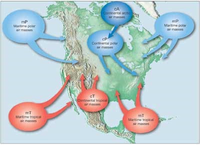
2. They describe an air mass by its Moisture content and Temperature, so each air mass has two letters. Name each air mass and describe it by moisture content and temperature.
cP = continental polar cT = continental tropical
mP = maritime polar mT = maritime tropical cA= continental artic
Using the map on the webpage, label each of the bubbles below.
a. Three air masses affect Pennsylvania’s weather the most. Name their air mass symbols and tell me where they come from. Maritime polar continental polar maritime tropical and parenthesis
2.
a. What causes an air mass to have a high pressure? ____________ air masses being cooled.
3.
a. What causes an air mass to have a low pressure?between warm and cool air mases near the ocean .
4. . Does air move from high pressure to low, or low to high? __________________high to low
Part 2. Global Winds
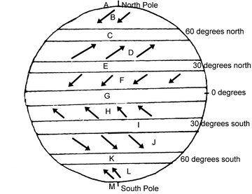
5. What are the Global Winds? 6 major wind belts 3 n each hemisphere pole to equator r the polar easterlies westerlies and trade winds Label B – L in the diagram below.
Part 3. Coriolis Effect
6.
a. Click on the “Pressure Gradient” link. What is the direction of the net force between two pressure systems? From pressure to pressure. high to low
b. Click on the “High” link. What is a High Pressure Center and what does it mean?pressure has been measured to be the highest relative to its surroundings
c. In the video, why does the ball not roll straight across the merry-go-round? cause it goes clock ways from pressure to another_________________
d. How is the Earth similar to the merry-go-round? (look at the figure) its round and we rotate in one way___________________________
e. Wind is an object that is affected by the Coriolis Effect. What happens to winds in the Northern Hemisphere as a results of the Coriolis Effect?imaginary force and clock wise _______________________.
7. Use the animation at the following website to help you find out how the Coriolis Effect affects wind: http://www.classzone.com/books/earth_science/terc/content/visualizations/es1905/es1905page01.cfm .
a. __________________high to low west to east__________________.
Part 4. Pressure Centers and Weather
8. Go to the website listed here: http://ww2010.atmos.uiuc.edu/(Gh)/wx/surface.rxml . Then, find the picture that says “Sea Level Pressure with IR satellite”. Click on this figure to bring up a new window. Click on the button that says “Aminate”. Choose “96 frames”. Answer the following questions:
a. This map shows you isobars and cloud cover. Click on the ? help to explain what an isobar is. __________is a line or air pressure and mass________________________ .
b. Look at the map and find Chicago. Between which two isobars is Chicago? _____high cold front___________________ .
c. Press “Play” on the window, and watch where the clouds travel. Do the clouds tend to be near High pressure centers (H) or Low pressure centers? ______________high to low______________.
9. This website will help explain why High pressure centers usually mean good weather, and Low pressure centers usually mean bad weather: http://www.usatoday.com/weather/tg/whighlow/whighlow.htm . Go here and read to discover why this is true, and then answer the following questions:
a. Air descends (comes down) at High pressure areas. Why does descending air not allow for clouds to form?________________dense___________
b. Air ascends (goes up) at Low pressure areas. Why does ascending air allow for clouds to form? ___________ .
less dense
c. Use diagram to determine the direction of wind motion. What is the direction around a High pressure system? west to east
d. What is the direction around a Low pressure system? east
Part 5. Frontal Boundaries
10. This website will help you to understand a frontal boundary. Read the Introduction at the top and answer the following questions. http://www.phschool.com/atschool/phsciexp/active_art/weather_fronts/
a. What is a weather front? boundary seperating two masses of air
11. Play the Cold front animation and read the information above to answer the questions below.
a. Which air mass is doing the pushing? cold front
b. What forms when the warm air gets pushed ”up” by the cold air? occluded front
c. What kind of clouds form at the frontal boundary? cumulus
d. What weather is associated with this cloud type? dry air moist surface
12. Play the Warm Front animation and answer the questions below.
a. Which air mass is doing the pushing? warm front
b. What forms when the warm air rides “up” over the cold air? stationary front
c. What kind of clouds form at this frontal boundary? sratus
d. What kind of clouds are at the very front edge of this boundary? cirus
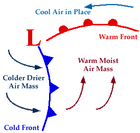
13. Below you will see on the weather map the symbol for a Cold Front is a Blue line with Triangles and a Warm Front is a Red line with half-circles. Label the diagram to show where the cool, dry (cP) air mass and the warm, moist (mT) air mass is in the picture.
a. Along which frontal boundary will thunderstorms develop? frontal squall line
b. Along which frontal boundary will all-day rain occur? shear lines stationary front
c. Look at the wind arrows on the diagram, do they match the direction of motion you determined in questions 9, d? What direction is that? yes east
14. What happens at a Stationary Front? two air masses neither advance
15. Search the internet to find out the weather map symbol for a Stationary Front and draw below.
16. Click on this website to see the Current Weather Map. http://www.weather.com/maps/maptype/currentweatherusnational/index_large.html
a. Where is a Cold Front occurring? west
b. Where is a Warm Front occurring? north
c. What type of air mass are we currently in? warm moist air mass
1
a. What is an airmass? An airmass is ______a body of air with horizontally uniform temp humidity and pressure ________
b. Explain the difference between a “continental(c) ” air mass, and a “maritime(m)” air mass. ___continental air mass;uniform temperatures and moisture profilepolar or tropical maritime air mass;uniform temperarture and moisture profile oceanic .
c. Explain the difference between a “polar(P)” air mass and a “tropical(T)” air mass.
Polar cold tropical warm land/water
2. They describe an air mass by its Moisture content and Temperature, so each air mass has two letters. Name each air mass and describe it by moisture content and temperature.
cP = continental polar cT = continental tropical
mP = maritime polar mT = maritime tropical cA= continental artic
Using the map on the webpage, label each of the bubbles below.
a. Three air masses affect Pennsylvania’s weather the most. Name their air mass symbols and tell me where they come from. Maritime polar continental polar maritime tropical and parenthesis
2.
a. What causes an air mass to have a high pressure? ____________ air masses being cooled.
3.
a. What causes an air mass to have a low pressure?between warm and cool air mases near the ocean .
4. . Does air move from high pressure to low, or low to high? __________________high to low
Part 2. Global Winds
5. What are the Global Winds? 6 major wind belts 3 n each hemisphere pole to equator r the polar easterlies westerlies and trade winds Label B – L in the diagram below.
Part 3. Coriolis Effect
6.
a. Click on the “Pressure Gradient” link. What is the direction of the net force between two pressure systems? From pressure to pressure. high to low
b. Click on the “High” link. What is a High Pressure Center and what does it mean?pressure has been measured to be the highest relative to its surroundings
c. In the video, why does the ball not roll straight across the merry-go-round? cause it goes clock ways from pressure to another_________________
d. How is the Earth similar to the merry-go-round? (look at the figure) its round and we rotate in one way___________________________
e. Wind is an object that is affected by the Coriolis Effect. What happens to winds in the Northern Hemisphere as a results of the Coriolis Effect?imaginary force and clock wise _______________________.
7. Use the animation at the following website to help you find out how the Coriolis Effect affects wind: http://www.classzone.com/books/earth_science/terc/content/visualizations/es1905/es1905page01.cfm .
a. __________________high to low west to east__________________.
Part 4. Pressure Centers and Weather
8. Go to the website listed here: http://ww2010.atmos.uiuc.edu/(Gh)/wx/surface.rxml . Then, find the picture that says “Sea Level Pressure with IR satellite”. Click on this figure to bring up a new window. Click on the button that says “Aminate”. Choose “96 frames”. Answer the following questions:
a. This map shows you isobars and cloud cover. Click on the ? help to explain what an isobar is. __________is a line or air pressure and mass________________________ .
b. Look at the map and find Chicago. Between which two isobars is Chicago? _____high cold front___________________ .
c. Press “Play” on the window, and watch where the clouds travel. Do the clouds tend to be near High pressure centers (H) or Low pressure centers? ______________high to low______________.
9. This website will help explain why High pressure centers usually mean good weather, and Low pressure centers usually mean bad weather: http://www.usatoday.com/weather/tg/whighlow/whighlow.htm . Go here and read to discover why this is true, and then answer the following questions:
a. Air descends (comes down) at High pressure areas. Why does descending air not allow for clouds to form?________________dense___________
b. Air ascends (goes up) at Low pressure areas. Why does ascending air allow for clouds to form? ___________ .
less dense
c. Use diagram to determine the direction of wind motion. What is the direction around a High pressure system? west to east
d. What is the direction around a Low pressure system? east
Part 5. Frontal Boundaries
10. This website will help you to understand a frontal boundary. Read the Introduction at the top and answer the following questions. http://www.phschool.com/atschool/phsciexp/active_art/weather_fronts/
a. What is a weather front? boundary seperating two masses of air
11. Play the Cold front animation and read the information above to answer the questions below.
a. Which air mass is doing the pushing? cold front
b. What forms when the warm air gets pushed ”up” by the cold air? occluded front
c. What kind of clouds form at the frontal boundary? cumulus
d. What weather is associated with this cloud type? dry air moist surface
12. Play the Warm Front animation and answer the questions below.
a. Which air mass is doing the pushing? warm front
b. What forms when the warm air rides “up” over the cold air? stationary front
c. What kind of clouds form at this frontal boundary? sratus
d. What kind of clouds are at the very front edge of this boundary? cirus
13. Below you will see on the weather map the symbol for a Cold Front is a Blue line with Triangles and a Warm Front is a Red line with half-circles. Label the diagram to show where the cool, dry (cP) air mass and the warm, moist (mT) air mass is in the picture.
a. Along which frontal boundary will thunderstorms develop? frontal squall line
b. Along which frontal boundary will all-day rain occur? shear lines stationary front
c. Look at the wind arrows on the diagram, do they match the direction of motion you determined in questions 9, d? What direction is that? yes east
14. What happens at a Stationary Front? two air masses neither advance
15. Search the internet to find out the weather map symbol for a Stationary Front and draw below.
16. Click on this website to see the Current Weather Map. http://www.weather.com/maps/maptype/currentweatherusnational/index_large.html
a. Where is a Cold Front occurring? west
b. Where is a Warm Front occurring? north
c. What type of air mass are we currently in? warm moist air mass
meteorology is the study of atmospheric phenomena
climate is the long term average of variations in weather for a particular area
certain tilt causes uneven heating
in balance heating due to tilt
maritime polar
continental polar
artic air mass
coriolois effect results in fluids and objects moving in an apparent curved path rather than a straight line
polar easterlies east to west
prevailing westerlies west to east
trade winds
intertropical zone
jet stream
front 4 types
cold front triangle
warm front circle
occluded front triangle circle
stationary front down triangle up circle
STATION MODEL RECORD WEATHER DATA FOR PARTICULAR SITE AT A PARTICULAR TIME
